
Multi-County Response to the Green Fire
On the morning of July 2, 2025, first responders were alerted to the report of a vegetation fire. Smoke was visible on the Round Mountain Shasta camera. Cole Euken, a staff reporter for Watch Duty, quoted Air Attack as the source of information for where the fire was headed–at the top of a ridge “in heavy dead and downed fuels, backing down the ridge.”
By late afternoon, the fire had grown to 15 acres, according to Euken, and had “high growth potential.” That night, helicopters worked on the fire. The next day, tankers and helicopters worked as the fire was mapped by CalFire at almost 97 acres. By night, the acreage doubled.
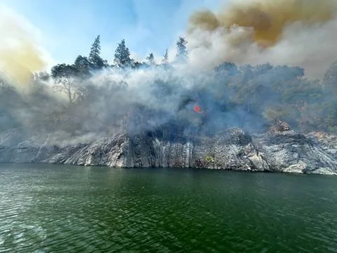
Firefighters travel by helicopter then boat
On July 4 around noon, the U.S. Forest Service for Shasta-Trinity National Forest (USFS) shared that 106 personnel had been assigned with Brent Kissick as Incident Commander and incident command trainee Nick Price. USFS explained that the fire was located near the Pit River arm of Shasta Lake, 13 miles east of Lakehead, California. The terrain was steep and rugged, so crews had to be flown in by helicopter and then taken by boat to reach the fire. At this point, the objective was to keep the fire north of the Pit River and south of Sierra Pacific lands.
The fire doubled yet again, and more resources were ordered. The containment was still at zero percent. The fire was mapped at 542 acres by CalFire, and by July 6, it was over a thousand acres. The firefighting went on for days. “Nocturnal down canyon winds in the Flat Creek drainage are also causing slow but active downhill fire through dry fuels,” explained the USFS on July 7. Helicopters continued to make water drops while firefighters worked with heavy equipment to create a containment line.

Fire perimeter as of July 7, 2025
The fire was growing mostly in the Flat Creek and Gray Rocks areas. By July 8, almost a week later, aircraft had completed 112 retardant drops, each drop containing 1,000 to 3,000 gallons. Helicopters had made more than 200 water drops on hot spots. “Firefighters are operating in some of the most challenging and difficult terrains in northern California, where access is only possible by boat across Shasta Lake, then by hiking in for over two hours,” the USFS wrote. The crews were dealing with extreme heat and steep slopes.
Growth to past 5,000 acres
More than a week had passed. By July 10, the fire was mapped at over 5,000 acres. The next day, it was at over 8,000 acres. And by the day after that, 1,018 personnel had been assigned with still zero percent containment. The vegetation that was fueling the fire was comprised of dormant brush (vegetation that is not actively growing), slash (woody debris left after cutting trees), and chaparral (dense, thorny shrubland).
On the east flank of the fire, crews improved the fireline along the Rip Gut Ridge. To the west, they improved the fireline along Brock Mountain Road. A Pit River group was placed to assess fire behavior to the south.
Collaboration toward containment
July 12 brought new hope: containment was reported at 5% and fire intensity and spread were expected to decrease overnight. Firefighters worked on consuming unburned fuel in front of the fire to slow the fire’s progression. The fire spanned more than 10,000 acres by this point.
Smoke was being pushed toward Redding by light winds from the north. Hazardous hair quality was expected, with winds helping to clear it up. The U.S. Air Quality Index was reported at 604 near Redding on July 14, a hazardous air quality level.
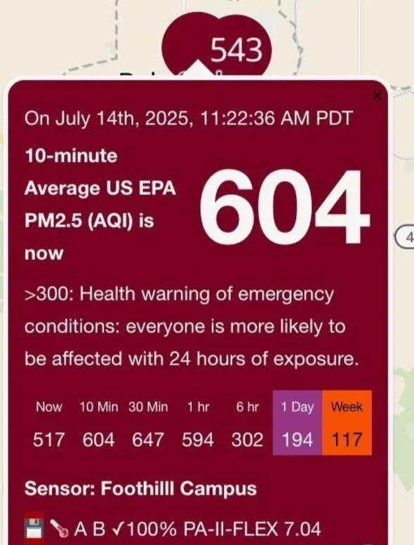
604 AQI reported near Redding
Redding City Councilmember Tenessa Audette commented, “Redding mornings have become a daily reminder of fire season—smoke hangs heavy, especially for kids, seniors, and those with health issues. While evenings bring some relief, the pattern stirs memories of the Carr Fire and reminds us how vulnerable we still are.”
The Green Fire as of the July 14, 2025. Photo: USFS Shasta-Trinity National Forest
By July 15, several fire departments had deployed engine companies to help with the Green Fire, including Grass Valley, Nevada City, North San Juan, Higgins, Roseville, Peardale Chicago Park, and CalFire’s Sonoma-Lake-Napa unit, among others. “They have spent a few days on the line providing structure protection, assisting with putting in a fire break by hand and laying down a hose lay to reinforce the fire break with water,” the Grass Valley Fire Department shared. They explained that their engine companies can be deployed for up to 14 days, which is typical of a mutual aid agreement involving the temporary sharing of resources. These limits ensure no agency is overburdened, the borrowing department does not rely on outside help indefinitely, and the lending department abides by labor contract restrictions.

Firefighters from surrounding counties help with the Green Fire. Photo by the Grass Valley Fire Department
By evening the Green Fire was mapped at nearly 15,000 acres with almost 10% containment.
“Weather monitoring is a critical fire management component when implementing firefighting tactics,” shared the USFS. “Weather balloons have sensors attached below the balloons that send information back to a computer accessed by meteorologists on the ground.” Weather balloons are able to travel above the smoke layer, which helps to gather useful data.
The northernmost part of California is experiencing several wildfires at this time in addition to the Green Fire, including the Butler Fire, and Jacket Fire near Orleans and the Summit Fire near Klamath National Forest.
Crews are still working as residents wait for more updates.